How Drone Captures Improve Construction Progress Tracking
Keeping a construction project on schedule requires reliable, frequent site updates. Traditional methods like ground photos or manual surveys give only a partial view, and they can miss subtle changes between visits. Aerial captures from drones offer a different approach: regular, repeatable imagery that lets teams compare conditions across the entire site at a glance. This article walks through the steps to set up drone captures for progress tracking and explains what to watch for at each stage.
Step 1: Plan Your Flight Schedule Around Project Milestones
The value of drone captures depends on consistency. Without a fixed schedule, you lose the ability to compare like-for-like snapshots. Tie each flight to a meaningful project event: after foundation pouring, before steel erection, or at the end of a work week. For most construction sites, a weekly flight works well, but critical phases may call for more frequent captures. The key is to fly the same area at roughly the same time of day to keep lighting conditions similar. This makes later comparisons easier and more reliable.
Step 2: Set Up Ground Control Points for Accuracy
Drone imagery is only as useful as its spatial accuracy. To align captures from different dates, place a few permanent ground control points (GCPs) around the site. These can be painted marks on concrete, survey targets, or even fixed features like manhole covers. The drone's software uses these points to georeference each image, ensuring that a coordinate today matches exactly the same spot next week. Without GCPs, small positioning errors accumulate, making it hard to detect subtle shifts or measure distances accurately. Spend time on this step early; it saves rework later.
Step 3: Capture Orthomosaics and Overlap Data
A single aerial photo covers only part of a construction site. To get a complete view, the drone flies a grid pattern, taking hundreds of overlapping images. These are stitched together into an orthomosaic: a single, distortion-free map of the entire site. The overlap (typically 70-80% front and side) ensures the stitching software can align features correctly. For progress tracking, request both the orthomosaic and the raw images. The orthomosaic gives you the big picture, while raw images let you zoom in on specific details like rebar placement or utility trench depth.
Step 4: Upload Captures to a Comparison Platform
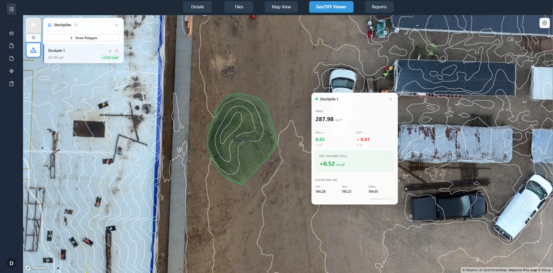
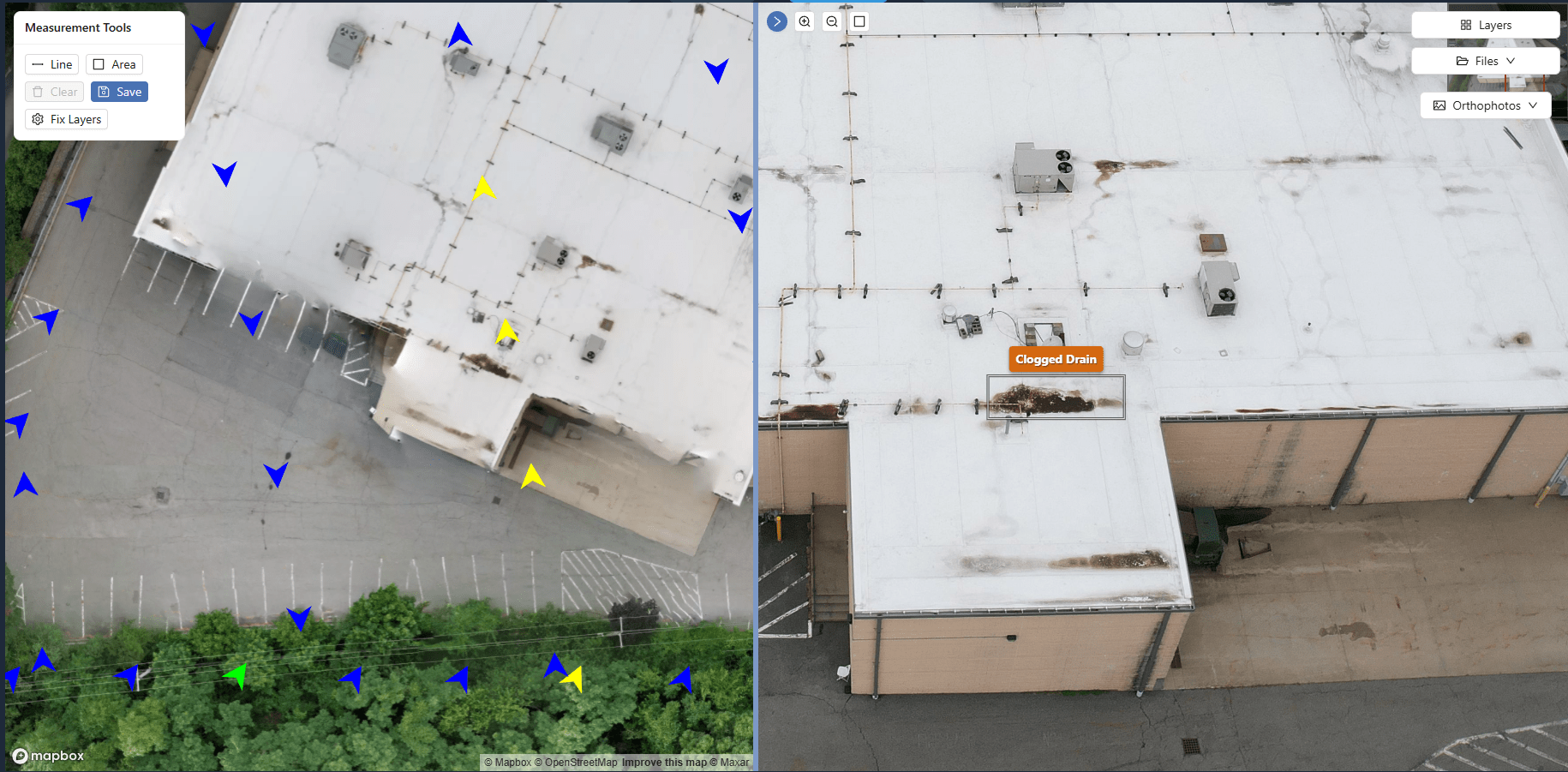
Raw image files are bulky and hard to manage on a local drive. Use a cloud-based platform (like DataDelivery's client portals) to upload, organize, and view your captures by flight date. These platforms typically offer side-by-side viewers, overlay tools, and annotation features. When you upload a new set, the system can automatically align it with previous flights, letting you slide back and forth to spot changes. This is where the concept of site capture comparison truly comes to life: you can flick between last month's foundation layout and today's steel frame, seeing exactly what has advanced and what has stalled.
Step 5: Perform Change Detection on Key Areas
Change detection tools highlight differences between two orthomosaics pixel by pixel. For example, if a new trench appeared between flights, the software can flag that area in red. This is especially useful for monitoring earthworks, stockpile volumes, or vegetation clearing. But change detection is not automatic; you need to set a tolerance for what counts as a change. Small variations in lighting or drone altitude can produce false positives. Adjust the sensitivity based on your site's typical activity. For a busy foundation stage, you might accept more noise; for a finished structure, you want tighter thresholds.
Step 6: Annotate and Share Findings with the Team
Raw data is not enough. Add site annotations to the captures: mark areas where work is behind schedule, note safety hazards, or highlight completed milestones. These annotations become part of the project record. Share the annotated captures with the project manager, subcontractors, and the client. A well-annotated orthomosaic communicates more than a dozen emails. It shows exactly what was done, where, and when. This transparency reduces disputes and helps everyone stay aligned on the next steps.
What to Watch at Each Stage
Every step has pitfalls. During flight planning, watch for weather that varies from your baseline; overcast skies can flatten shadows and make change detection less reliable. When setting GCPs, ensure they are visible from the air and not obscured by tall equipment or materials. During image processing, check the orthomosaic for stitching errors near edges or over reflective surfaces like water or glass. On the comparison platform, verify that the alignment is correct before drawing conclusions; a misaligned layer will show false movement. And when annotating, keep a consistent legend so everyone interprets the same markers the same way.
Integrating Drone Captures into Regular Reporting
Once you have a routine, integrate the captures into your existing reporting cycle. For instance, include a weekly orthomosaic with annotations in the project dashboard. This provides a visual record that supports map-based progress reporting for projects without extra effort. The same data can feed into timeline updates, budget reviews, and client meetings. Over time, you build a historical library that helps with future planning: you can see which phases consistently cause delays and adjust your schedule accordingly. This kind of evidence-based decision making is hard to achieve with photos alone.
Choosing the Right Capture Frequency
There is a trade-off between detail and data management. Too many flights overwhelm storage and processing time; too few leave gaps in the timeline. A good starting point is weekly flights during steady-state construction and bi-weekly or monthly after structural completion. Adjust based on the project's pace and the stakeholders' need for updates. Remember that the goal is not to document every shovel of dirt, but to capture meaningful milestones that allow accurate progress tracking. Discuss with your team which phases need higher frequency and where you can relax the schedule.
Using Captures for Accountability and Quality Control
Drone captures also serve as an impartial record. If a subcontractor claims certain work was completed, the orthomosaic can confirm or refute that claim. This reduces arguments and speeds up payment approvals. On the quality side, you can inspect hard-to-reach areas like roof assemblies or tall facades without sending someone up a ladder. Look for signs of water ponding, uneven grading, or misaligned elements. Catches made early are cheaper to fix. The captures become a permanent, timestamped log that supports both daily operations and final handover documentation.
Bringing It All Together: A Practical Workflow
To summarize, the workflow looks like this: plan flights around milestones, set up GCPs for accuracy, capture orthomosaics with proper overlap, upload to a platform that allows site capture comparison, run change detection on critical areas, annotate findings, and share with the team. Each step builds on the last, and the output is a clear, visual timeline of the project's progress. This approach turns raw aerial data into actionable insights. Over several projects, you will develop a library of comparisons that helps you estimate future timelines more accurately and spot patterns that affect productivity.
For teams that adopt this method consistently, the result is a transparent, data-driven view of construction progress. Instead of relying on memory or scattered photos, everyone works from the same up-to-date map. This supports map-based progress reporting for projects at every level, from the site supervisor to the client. The investment in drone captures pays off in fewer misunderstandings, faster decision making, and a reliable record that stays useful long after the project ends.